“Together we have a stronger voice.”
Statement Regarding Proposal to Remove Seven Parcels from the Central Street Overlay District
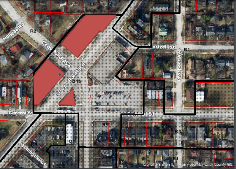 City staff has proposed to remove seven parcels at Central/Crawford/Gross Point from the Central Street Overlay District.
Application 22PLND-0038 was before the Land Use Commission on 6/22/2022 (Youtube link) and the hearing has been continued to the Land Use Commission meeting on 7/13/22.
Statement from Jeff Smith, President of CSNA
(download full document with referenced images)
I am a 32-year resident of north Evanston and am currently the president of the Central Street Neighbors Association (“CSNA”). CSNA for 15 years has been the largest community organization in north Evanston, one of the largest in all of Evanston, and represents members with over two thousand collective years of experience living in the area and an investment of, conservatively, over $40 million in local property. Almost every member, if not every member, of CSNA uses the Crawford - Gross Point - Central intersection. Both I and CSNA were deeply involved in the planning and zoning implementation that led to the zoning of what was called Subarea 6 in the award-winning Central Street Master Plan.
This Commission should reject the proposal in Agenda Item IV(a), Map Amendment 22PLND-0038, to remove that area from the Central Street Overlay District. Such an act would be contrary to City planning, inconsistent with the overall purpose of our zoning, would increase danger to public safety, and would undermine the balanced tradeoff of setbacks-for-upzoning that was arrived at through a long public and deliberative process in 2007-08, agreed upon by a unanimous City Council. The proposed map amendment is unsupported by study of present and future traffic or any other impacts. As such, it would be arbitrary and capricious.
Moreover, unlike the 2007-08 process, there has been little public discussion; residential stakeholders have not been broadly invited to participate, only provided with inconsistent and impersonal “notice of a public meeting.” The property rights of those affected require further opportunity to respond to any presentation made this evening, at subsequent meeting.
This proposal would not be advancing if any of the advocates had been involved in the process that led to the current zoning. The following is necessary factual context.
Staff, residents, planning consultants, and City Council all recognized in 2007-08 that the “West End” of Central Street, at the intersection of Gross Point, Crawford, and Central, had different considerations than that of the business and residential districts to the east. See excerpts from Master Plan, attached as Exhibit 2. All these continue today:
- Traffic volume. The dominant influence on the subarea is its high-volume intersection of three major roads, handling over 20,000-30,000 or more vehicles daily, including much coming to and from two of Evanston’s largest employers, Northwestern University and Evanston Hospital. This traffic needs to flow smoothly and continuously.
- Traffic Speed. Traffic approaching the intersection is often heading to or from I-94, and is coming from relatively long (1/2 mile or more) stretches of higher-speed-limit, low cross- traffic road along golf course, cemetery, or parks, and as such is at higher speed than at more congested Evanston intersections.
- Most traffic at the intersection is through rather than destination traffic.
- A Complicated Intersection. The geometry of the intersection, with traffic entering from six different directions and a majority making a turn within the intersection, with a sole business building standing in a triangle in the very middle of the street, is unique within Evanston if not the region, posing challenges for drivers.
- The roads entering the intersection have several changes in width before and after the intersection.
- Elevation Changes. Vehicles face sudden changes in elevation turning from Gross Point or Crawford onto Central, or from Central to the north, also unique to Evanston. See photos at Exh. 1, attached.
- Sight Lines. The intersection is at a relative high point, such that traffic coming down Crawford from Wilmette and through the Hillside community, eastbound traffic on Central which is climbing toward the intersection, and traffic coming up Crawford cannot see each other until at the intersection. Traffic turning east off Gross Pointe may suddenly have to come to a stop at Crawford. Sight lines and views of other traffic are further impeded by the hot dog stand in the middle of the intersection and the extension of the northwest wall of the CVS building toward Ridge. See photos at Exh. 1, attached.
- Crash History. The intersection has been ranked as one of Illinois’s most dangerous and has been the scene of some horrific accidents.
- Counterintuitive Development. Some of the existing built environment would not be built, or would not be built to existing dimensions, under modern planning or traffic principles.
- The intersection in 2007-08 was already experiencing additional challenges as a result of the development of the small strip mall at the southeast corner.
As a result of all the above, there was no push or general request by residents to try and replicate the walkable mom-and-pop mixed-use retail feel of business districts to the east. Residents had no problem with the existing “C” commercial zoning, which by its low floor area ratio (“FAR”) limited building massing and also allowed for needed auto-service and other establishments.
Residents felt that adding more entering-and-exiting cross-traffic and pedestrians to the intersection was not wise, although more could be done to make the intersection more pedestrian-friendly, attractive, and more of a gateway to Evanston. The changes in zoning to a Business district were driven by staff, and, on information and belief, a single developer who wanted to build a multistory mixed-use structure at the intersection.
The consistent position of the Central Street Neighbors Association was that the subarea should preferably remain Commercial, but if rezoned to Business, should at most be zoned B1a. See Exhibit 3, attached. However, CSNA and residents also recognized that the large CVS site and the former Citgo gas station site, in conjunction with the Sarkis lots, the parking lot to Sarkis’s northeast, and/or or the empty lot to the north of Sarkis, potentially could support modest, more affordable multifamily housing in a mixed-use development, potentially attractive to university or hospital workers or even downtown Evanston workers if supported by transit.
The solution and tradeoff arrived at was to rezone to Business, but with constraints. The “West end” of the overlay district was "upzoned" by changing the base zoning from a "C" commercial district to a B1a business district that had the taller height limits of a B2 district. This would allow up to a 4-story building. While CSNA preferred lower height, CSNA accepted the changes as consistent with the Master Plan approved by the Plan Commission and the City Council.
However, the development was understood to be “controlled” in that “any development at the intersection of Gross Point & Crawford must be set back 30' from the street and have stepbacks above the second floor.” See Exhibit 4, attached.
It is important to note that the Floor Area Ratio of the commercial district prior to rezoning was 1.0. The subarea was not downzoned by way of the overlay district nor due to neighborhood demands. The zoning implementation of the Master Plan allowed, to the contrary, for greater development, while sensibly pushing that development away from the high-traffic intersection for safety reasons.
To simply remove the overlay district provisions would convert the 2008 zoning to a sheer upzoning that had no public support, with increased congestion and danger, without any corresponding benefit for drivers, pedestrians, cyclists, or those who live nearby.
The need for safety at the intersection becomes even stronger if a school with daily traffic and the presence of children, many of whom might be walking to school, is to replace the low impact of a church that has significant traffic only once a week.
The 2007 planning and the 2008 rezoning, and the implementation of the overlay district with its specific provisions for Subarea 6 was the result of a comprehensive process that involved four separate community workshops, extensive public debate and discussion, the participation of community groups and collectively hundreds of person-evenings, well over a thousand hours of citizen review and comment, and well-covered discussion within the community and on the City’s planning and legislative bodies. If the initial adoption of B1a in 2005 is included, what was implemented at the intersection can be seen as the result of nearly three years of analysis, planning, and discussion. It was well understood in 2008 that the process of application for variation would allow flexibility in cases of demonstrated need while protecting the rights and safety of residents. To jettison all that by way of map amendment without any significant change in circumstances, without any demonstrated need, with no impacts studies, without any comparable process, and with no evident driver other than that a restaurant with plenty of space wants more outdoor dining, would be counter to Evanston plans, fundamental planning principles, the goals of existing zoning, arbitrary, and capricious.
— JPS 6/22/2022
- Log in to post comments